Accurate Volume Measurement – The Reason why half of the largest mining companies Use PIX4D mapper – A GEOmatic Development case

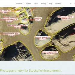
Drone Photogrammetry for Stockpile Measurement The biggest 40 mining companies were announced in PWC’s latest mining report, and nearly half of these companies use drone photogrammetry software (Pix4Dmapper Pro) as part of their mining workflow. Managing stockpile inventory, that is, finding a solution for accurate volume measurement and easy inventory management, is one of the[…]

Why this type of drone?

Why have we chosen this particular type of drone? We strive to personalise image acquisition and in that respect the advantages of the drone seemed clear. Yet, in this fast moving area, we had choices to make in order to fit the needs of geographical data and cartography. Flying wing drones offer a greater flight[…]

Vineyards – European VINTAGE project

Our missions in precision farming lead us to collaborate with the European Research Project VINTAGE, http://www.vintage-project.eu/. This project is a collaboration between universities, research units and thousands of professional wine producers. The aim of this project is to make available to these producers a web-based integrated solution to optimize the vineyard life cycle from planting[…]